History · Archaeology

The Empire That Ate the Andes

New tunnels, binary quipus, and a mathematical autopsy of history's most misunderstood superpower.

Listen
Machu Picchu at golden hour with dramatic Andean peaks rising through clouds behind the ancient stone terraces
Illuminated manuscript pages showing colorful illustrations of Inca rulers
01

A 400-Year-Old Eyewitness Finally Speaks English

Here's a thought experiment: imagine the most detailed account of the American Revolution existed only in Mandarin. That's roughly what English-speaking scholars have been dealing with for four centuries when it comes to Martín de Murúa's General History of Peru. The first complete English translation of Book 1 arrived in March 2026, and it's the kind of primary source that makes historians rethink their bibliographies.

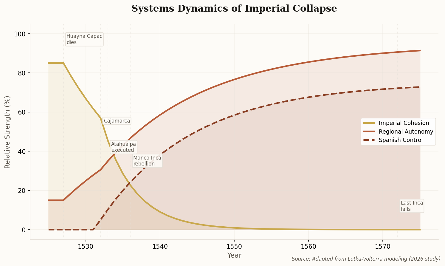
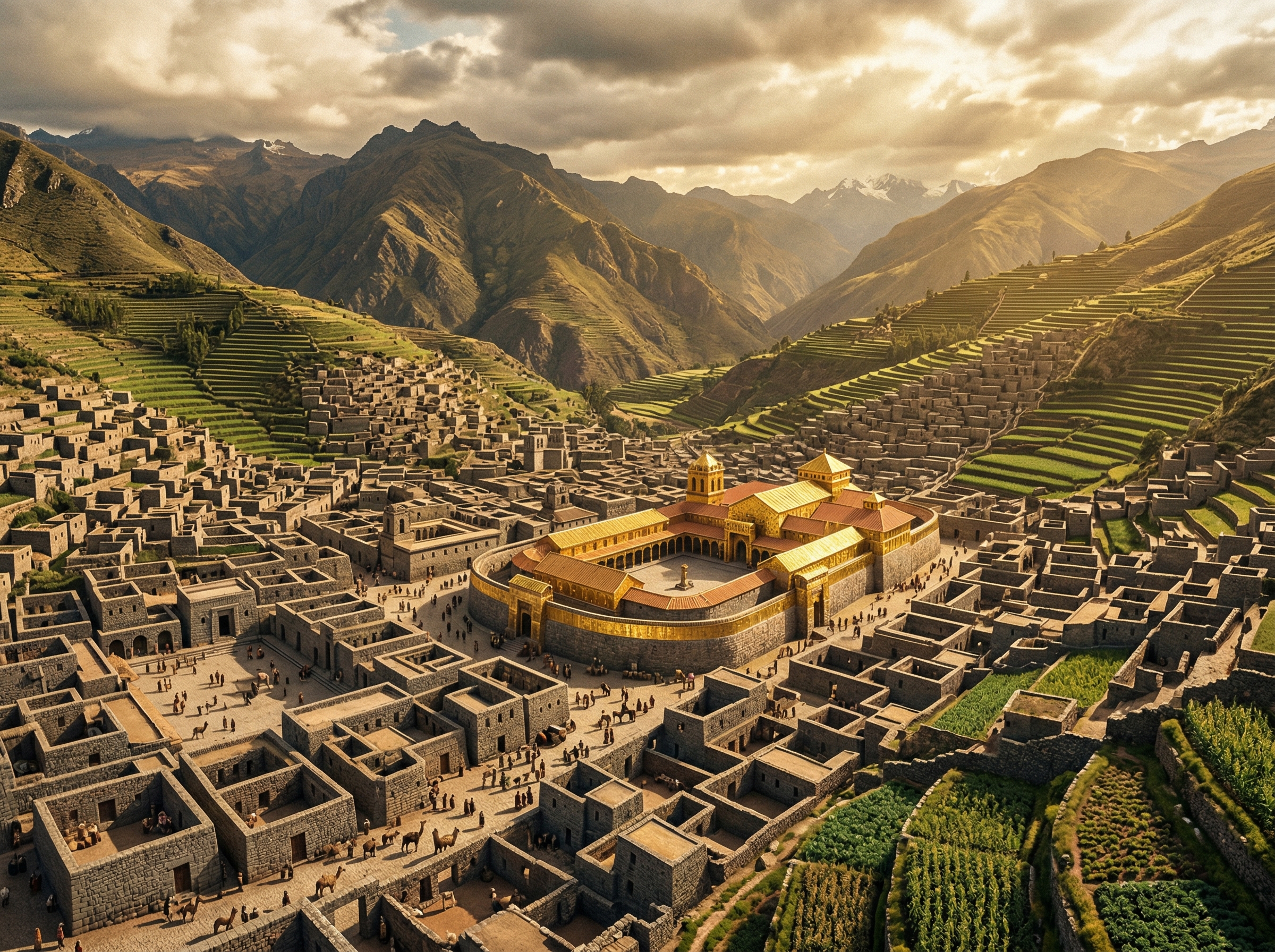
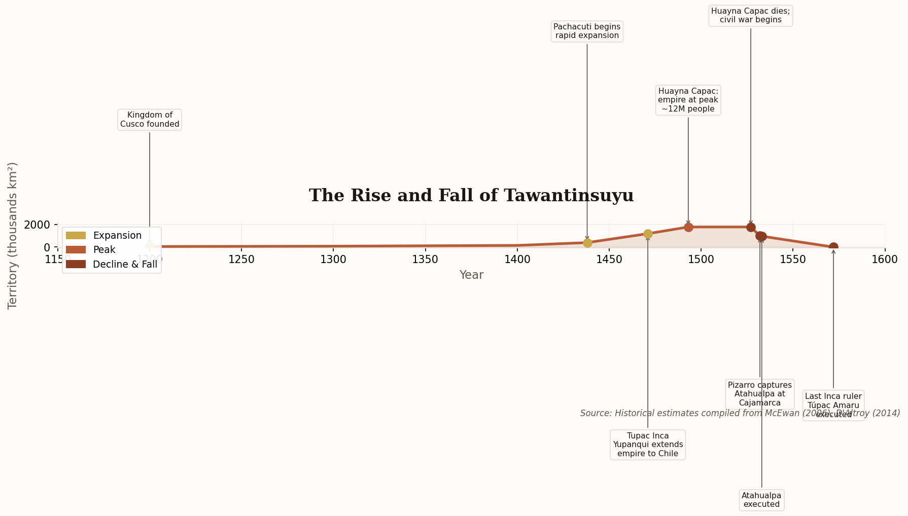
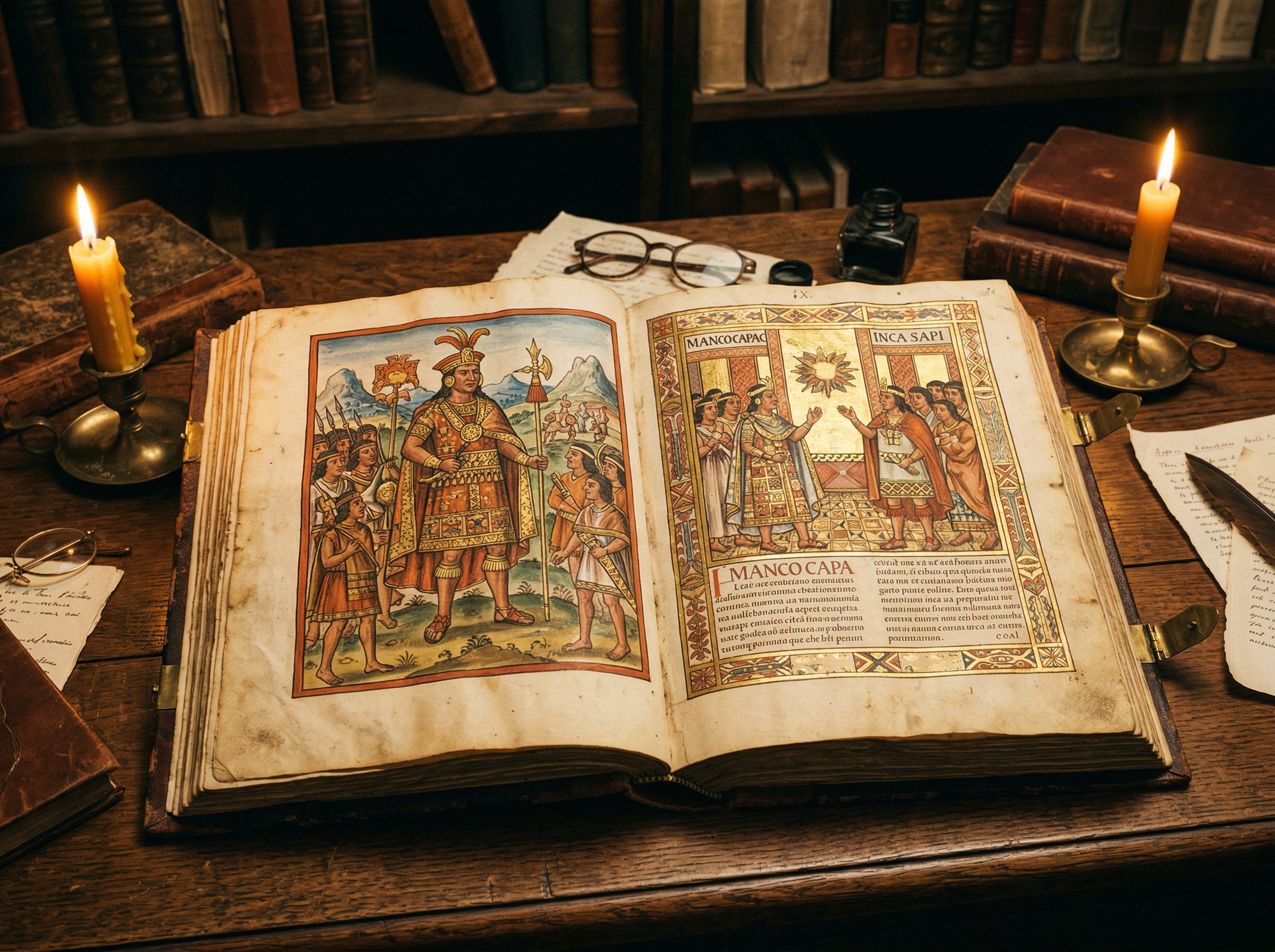
Murúa wasn't some distant chronicler. He was a Mercedarian friar living among the Inca's descendants in the late 1500s, and his 1616 manuscript contains the most granular accounts we have of the Sapa Incas' inner lives — their court politics, their succession crises, their ceremonial calendars. It also contains the famous "Murúa Murals," hand-painted illustrations that provide some of the only visual evidence of Inca clothing and ritual practice.

The translation matters because cross-referencing primary sources is how history self-corrects. Until now, English-language scholarship on the Inca has been disproportionately built on Garcilaso de la Vega and Cieza de León. Adding Murúa to the mix doesn't just fill a gap — it creates productive contradictions that force better questions. Expect the next generation of Inca scholarship to look very different.

Machu Picchu ruins with environmental monitoring sensors and receding glacier backdrop
02

Saving the Stone City From the Melting Mountain

Peru's Ministry of Culture approved a new strategic plan for Machu Picchu that reads less like a tourism document and more like a climate adaptation playbook. The Machu Picchu Master Plan 2026–2031 confronts two existential threats simultaneously: the accelerating retreat of the Salkantay Glacier and the steady erosion of stonework under 1.5 million annual visitors.

The plan's most striking feature is its engineering philosophy. New seismic sensors will be installed throughout the site — but rather than bolting modern tech onto ancient walls, the design draws inspiration from the Inca's own dry-stone construction techniques, which were built to flex during earthquakes rather than resist them. It's a rare case of 600-year-old engineering informing 21st-century conservation.

Then there's the AI-powered visitor management system: real-time "dynamic capacity" controls that adjust how many people can enter specific zones based on weather, humidity, and stone degradation data. It's not just crowd control — it's a bet that the site can survive another century if we stop treating it like a theme park and start treating it like what it is: an irreplaceable geological-architectural hybrid that's already outlived the civilization that built it.

Colorful Inca quipu knotted strings with mathematical patterns suggesting computational logic
03

The World's First Portable Computer Was Made of String

The Western definition of "literacy" has always been a rigged game. You need a phonetic alphabet to count as literate. By that standard, the Inca — who governed 12 million people across 1.8 million square kilometers — were illiterate. New interdisciplinary research published in early 2026 suggests they were anything but.

The study argues that quipus — the knotted string devices long acknowledged as accounting tools — operated on principles strikingly similar to binary data processing. Knot positioning, twist direction (S-twist vs. Z-twist), and color coding created a multi-dimensional information system capable of storing complex qualitative data, not just tallies — a tactile database with a query language built into the physical act of reading.

Infographic showing the four quarters of the Inca Empire (Tawantinsuyu) with key facts: founded c.1200, peak territory 1.8M km², population 12M, 40,000 km road network, no written language but used quipu, 200+ ethnic groups unified
Tawantinsuyu at its peak: four quarters, one system, zero written words — Generated with Nano Banana 2.0

The implications are enormous. The Inca managed a 40,000-kilometer road network rivaling Rome's, coordinated labor drafts across hundreds of ethnic groups, and ran a redistributive economy of staggering complexity — all on string. The researchers frame it provocatively: "The Inca may have been the first civilization to use a portable, tactile computer network to manage an empire." The debate over whether quipus encoded narrative language (not just numbers) remains open, but one thing is clear — the binary between "literate" and "illiterate" civilizations is itself illiterate.

Fragmenting Inca empire map with mathematical curves overlaid suggesting systems modeling
04

The Empire Was Already Dying Before Pizarro Showed Up

Here's the story you were taught: 168 Spanish soldiers with horses and guns conquered an empire of millions. It's a great story. It's also a fairy tale that flatters European military genius while erasing everything else that was going on in 1532.

A 2026 study applied Lotka–Volterra dynamics — predator-prey mathematical modeling typically used in ecology — to simulate the Inca collapse. The results are sobering. The civil war between Huáscar and Atahualpa had pushed the empire into a state of "systemic fragility" well before Pizarro arrived at Cajamarca. The model suggests that even without the Spanish, Tawantinsuyu would likely have fractured into smaller regional states within a decade.

Systems dynamics chart showing three curves — Imperial Cohesion declining sharply after 1527, Regional Autonomy rising, and Spanish Control emerging after 1532 — illustrating how the empire was already fragmenting before Spanish arrival
Lotka-Volterra modeling of the Inca collapse: imperial cohesion (gold) was already in freefall before the Spanish (dashed) arrived. Regional autonomy (terracotta) was the real winner.

The researchers' most quotable line: "The Spanish didn't topple a stable empire; they provided the catalyst for a system already in the process of thermodynamic failure." That's not a defense of colonialism — it's a more honest accounting of what happened. Empires don't collapse because 168 men are brave. They collapse because centralized systems are inherently fragile, and succession crises are the earthquake that finds every crack. Pizarro didn't defeat the Inca. He walked into a burning building.

Spectacular 3D reconstruction of the Inca capital Cusco at its peak with the golden Coricancha temple
05

Cusco Gets Its Close-Up (Finally)

National Geographic's multi-part series Incas: The Rise and Fall dropped in late 2025, and it does something no documentary about the Inca has managed before: it shows you the empire at its height, not just its ruins. Using the 2025 LiDAR survey data, the production team built the first fully accurate 3D digital reconstruction of Cusco — and it's stunning. The Coricancha gleams with gold plating. The streets are dense, organized, alive.

Side-by-side comparison of five contemporaneous empires circa 1500 CE showing territory size and population, with the Inca highlighted in terracotta
Tawantinsuyu in context: smaller than the Ming or Ottoman empires in territory, but governing a comparable population with zero written language and no wheeled vehicles.

The series centers on Pachacuti, the ninth Sapa Inca who transformed a modest Andean kingdom into a continental superpower in a single generation. Think of him as the Alexander the Great that history textbooks forgot. Under Pachacuti, the Inca expanded from the Cusco Valley to control an area larger than the Eastern Seaboard of the United States — in roughly 30 years, without horses, without iron, and without writing.

The most powerful moment in the series comes not from the expansion, but from the framing. As one historian notes on camera: "We are finally seeing the Inca not as a primitive culture that was conquered, but as a superpower that was interrupted." That's the kind of reframing that shifts how a generation thinks about pre-Columbian America. It's overdue.

Dense jungle canopy being penetrated by LiDAR scan lines revealing hidden Inca stone structures underneath
06

Machu Picchu Wasn't Alone — It Had Suburbs

The "lost city" narrative has always been a colonial fantasy — Hiram Bingham didn't "discover" Machu Picchu in 1911; local farmers had been cultivating its terraces the whole time. But even by revisionist standards, the 2025 LiDAR findings are a revelation. Drone-mounted LiDAR scanners cut through the jungle canopy to reveal 12 previously unknown structures hidden within five miles of the main citadel.

The most significant find is the expansion of the Chachabamba complex: 14 ritual baths and a sophisticated water management system that operated independently of Machu Picchu's own hydraulic network. This isn't a satellite outpost — it's a fully autonomous ceremonial center, running on the same engineering principles but with its own water supply, its own drainage, its own logic.

Timeline chart showing the rise and fall of Tawantinsuyu from 1200 to 1572, with territory growth peaking at 1.8 million square kilometers under Huayna Capac before rapidly declining
From highland kingdom to continental empire in three generations — then collapse in forty years. The Inca's trajectory remains one of history's most dramatic arcs.

The researchers frame it well: "We are realizing that Machu Picchu was not an isolated retreat, but the nerve center of a vast, interconnected ceremonial landscape." In other words, what Bingham found wasn't the city — it was the downtown. The suburbs were hiding under the trees the whole time.

Underground Inca stone tunnel corridor with trapezoidal doorway lit by flickering torchlight
07

The Subterranean Capital They Said Didn't Exist

For 500 years, Spanish chroniclers described a vast underground network beneath Cusco called the Chincana — and for 500 years, mainstream archaeology dismissed it as myth, legend, indigenous exaggeration. In January 2025, ground-penetrating radar put the debate to rest.

The GPR survey identified a primary corridor stretching 1.6 kilometers, connecting the Coricancha (Temple of the Sun) directly to the Sacsayhuamán fortress on the hill above. Estimates suggest the network contains over 8,000 meters of carved stone galleries — a subterranean city running parallel to the one on the surface.

The discovery validates oral histories that colonial scholarship spent centuries dismissing. The Inca didn't just build on the landscape — they built into it. Their architectural mastery extended below ground to create what one researcher calls a "subterranean capital" aligned with celestial observation points above. It's a perfect bookend for this newsletter: the more we look at the Inca with honest eyes, the more we find. The myth turns out to be the understatement.

The Interrupted Superpower

The Inca built 40,000 kilometers of road rivaling Rome, governed more diversity than the Habsburgs, and ran a continent-scale economy on knotted string. They did it without writing, without wheels, without iron. The story of their fall has been told as a parable of European superiority for 500 years. The story of their rise — the real one, the one hiding under the jungle canopy and inside the mountain — is only now being told. Pay attention. It's better than the myth.

Share X LinkedIn